


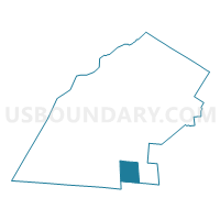
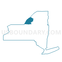
Voting District 120001, Jefferson County, New York
About
Outline

Summary
| Unique Area Identifier | 627539 |
| Name | Voting District 120001 |
| County | Jefferson County |
| State | New York |
| Area (square miles) | 39.00 |
| Land Area (square miles) | 38.98 |
| Water Area (square miles) | 0.02 |
| % of Land Area | 99.95 |
| % of Water Area | 0.05 |
| Latitude of the Internal Point | 43.74670320 |
| Longtitude of the Internal Point | -75.97813420 |
Maps

Graphs
Select a template below for downloading or customizing gragh for Voting District 120001, Jefferson County, New York


Neighbors
Neighoring Voting District (by Name) Neighboring Voting District on the Map
- Voting District 010002 010005, Jefferson County, NY
- Voting District 030001, Oswego County, NY
- Voting District 080001, Jefferson County, NY
- Voting District 170001, Jefferson County, NY
- Voting District 230001, Jefferson County, NY
Top 10 Neighboring County Subdivision (by Population) Neighboring County Subdivision on the Map
- Adams town, Jefferson County, NY (5,143)
- Ellisburg town, Jefferson County, NY (3,474)
- Rodman town, Jefferson County, NY (1,176)
- Lorraine town, Jefferson County, NY (1,037)
- Boylston town, Oswego County, NY (549)
- Worth town, Jefferson County, NY (231)
Top 10 Neighboring Place (by Population) Neighboring Place on the Map
Top 10 Neighboring Unified School District (by Population) Neighboring Unified School District on the Map
- South Jefferson Central School District, NY (11,237)
- Sandy Creek Central School District, NY (5,720)
Top 10 Neighboring State Legislative District Lower Chamber (by Population) Neighboring State Legislative District Lower Chamber on the Map
Top 10 Neighboring State Legislative District Upper Chamber (by Population) Neighboring State Legislative District Upper Chamber on the Map
Top 10 Neighboring 111th Congressional District (by Population) Neighboring 111th Congressional District on the Map
Top 10 Neighboring Census Tract (by Population) Neighboring Census Tract on the Map
- Census Tract 618, Jefferson County, NY (6,954)
- Census Tract 624, Jefferson County, NY (4,479)
- Census Tract 201, Oswego County, NY (3,543)
- Census Tract 625, Jefferson County, NY (3,494)
Top 10 Neighboring 5-Digit ZIP Code Tabulation Area (by Population) Neighboring 5-Digit ZIP Code Tabulation Area on the Map
- 13605, NY (4,777)
- 13083, NY (1,809)
- 13661, NY (1,646)
- 13682, NY (877)
- 13659, NY (593)
- 13674, NY (126)